Author:
Jen Rogers @jen33travel and Jenrogers33.com
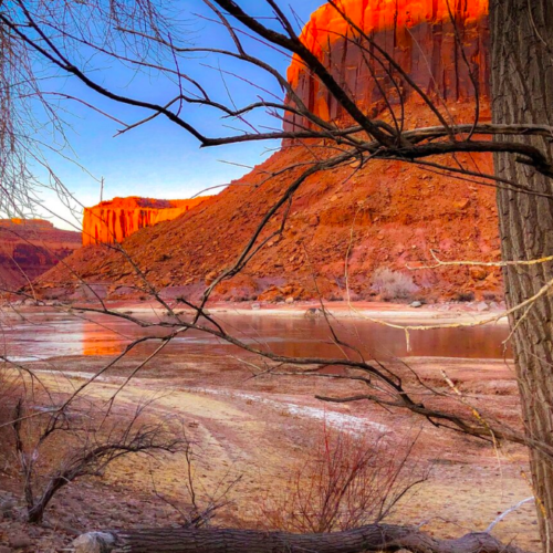
Canyonlands is over 330,000 acres of dramatic desert in southeastern Utah. Its sandstone walls were carved out by the Colorado River and its tributaries much like Grand Canyon and eroded with time, leaving behind an Island in the Sky, a huge flat-topped mesa full of panoramic outlooks, and miles of maze-like canyons, sheer cliff drop-offs, pinnacles and flats.
Canyonlands is so vast that it’s divided into distinct districts – Island in the Sky, The Needles, The Maze, Horseshoe Canyon Unit and the rivers that divide them. It literally takes hours traveling between the districts so unless you have unlimited time, you may want to consider focusing solely on one district for each visit to the park. Despite their proximity as a crow flies, there are no roads directly linking the districts together. It can take 2-6 hours by car traveling between them with limited spots that allow river crossing.
Canyonlands is open all day every day, 365 days a year. It never closes.
Plan Ahead:
Canyonlands is unlike most other national parks in that it is very isolated and extremely vast. It requires much more planning than most. This is not to say you can’t do a quick visit and drive through parts of it, but if you really want to spend some time there, you will definitely want to do your research. Below are some important things to know and consider before going.
4 Wheel Drive
Most of Canyonlands is inaccessible without a high clearance, low range four-wheel drive vehicle. Many roads are considered extremely technical to navigate and may experience flooding, snow, ice, deep sand, ledges and rock falls. Road conditions can change quickly and unexpectedly. Back country roads with obstructions and hazards may take maintenance a while to clear. Often times, chains and winches become necessary.
Roads requiring 4WD include: Elephant Hill, Salt Creek, Horse Creek, Davis Canyon, Lavender Canyon, Colorado Overlook, and the White Rim.
Permits
Much of Canyonlands is undeveloped rugged terrain. All overnight trips into its backcountry require permits which may be challenging to obtain during peak season (spring and fall). Reservations are not required but are highly recommended as space is limited.
Take water
Water is an extremely scarce resource within the boundaries of the park. Although water is available at the Island in the Sky and Needles Visitor Centres, there is no water available elsewhere so be sure to bring plenty with you.
Canyonlands is a dry desolate place, and can be extremely hot in the summer when temperatures can easily reach over 100° F. Come prepared. Note that even the Rangers Stations do not have water.
Temperatures
Canyonlands is considered a high desert meaning temperatures drop dramatically from day to night, as much as 40° F in a single day during all times of year. So, be sure to check the weather before leaving home.
Winters in Canyonlands can be extremely cold. Temps rarely reach over 50° F in the day and often drop near zero at night. Snow is rare and quite beautiful but be warned, even a light snow can close trails and make roads impassable. When traveling in Winter, always check road conditions in advance.
Summers in Canyonlands can reach scorching temperatures of over 100° F and often see summer monsoons with flash floods. If you plan to visit in the summer, bring plenty of water, do not engage in extremely strenuous exercise and if rain is predicted, avoid areas like slot canyons and locations prone to flash floods.
Spring and Fall are the best times to visit. From April to May and September to October, highs average 60-80° F and lows average 30-50° F.
If you’re not camping, nearby Moab is the best base.
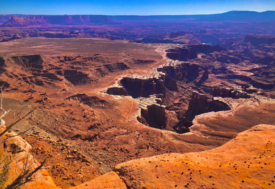
Island in the Sky
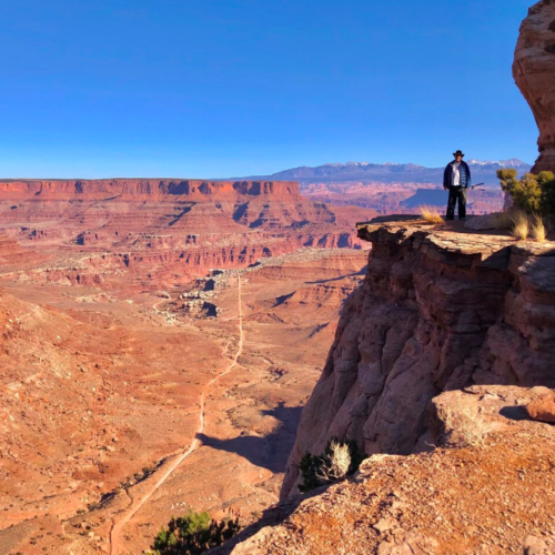
The Island in the Sky mesa sits atop 1,000 foot tall sandstone cliffs overlooking the valley below. There are numerous scenic outlooks along the island each offering unique perspectives of the picturesque canyons that were carved out below.
Island in the Sky is the most accessible part of the park. It is close to Moab and most of it is easily accessible without 4-wheel drive. There are paved scenic drives with numerous hiking spots. It’s a perfect spot for a day trip or if you have limited time.
Things to Do
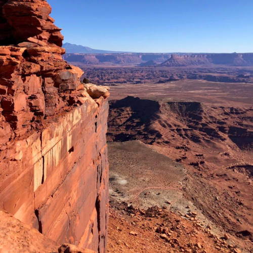
Grand View Point Overlook – Have you ever stood at the edge of the ocean feeling ever so small in this vast universe of ours? A hike to Grand View Point Overlook will magnify that feeling times ten. The overlook sits at the end of a mile-long sandstone staircase offering panoramic views of red rock spires against azure skies. It is at the southernmost point of the island with sweeping views of distant mountains, basins and canyons as well as White Rim Road.
Mesa Arch
Mesa Arch sits right on the edge of a 500-foot cliff with vast canyon views. The La Sal Mountains off in the distance provide a magnificent backdrop. It’s quite popular at dawn as the sun rises on the horizon behind the arch lighting up the red sandstone in golden tones.
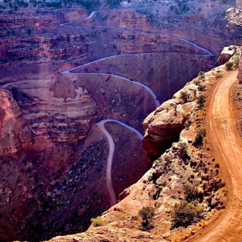
Shafer Trail
If you’re traveling through Canyonlands in a 4WD vehicle or mountain biking, Shafer Trail is an incredible unpaved backcountry road that will leave you in awe and provide opportunities to see wildlife. If not, you will still want to travel to the turn off to get a great view of the iconic route as it winds down 1,500 feet of colorful sandstone walls along a massive cliff.
The Needles
The Needles is an area of incredibly beautiful backcountry but to reach its hidden gemstones, you will need 4-wheel drive or a boat to access it. Hiking in this District is also more strenuous than other areas of the park.
The Needles is renowned for its incredible pinnacles and pictographs and a perfect area for backpacking.
Things to Do
Lavender Canyon
The road through Lavender Canyon follows the canyon bottom and is full of deep sand, deep water and quicksand. If you have the vehicle to navigate it, the hazards are worth exploring this incredible area as there are a wealth of arches and archaeological sites to see, some of which can be seen right off the road.
The road is usually too sandy for mountain bikes and includes two major creek crossings with steep banks. A backcountry permit is required even for day use.
Elephant Hill Trail
Elephant Hill is probably the most technical four-wheel drive road in all of Utah. The road is full of steep grades, loose gravel, stair-step drops and hairpin turns. It’s quite tricky to maneuver.
The trail is about 14.5 miles long. Maximum vehicle length including racks is 21 feet and 4WD is mandatory.There is no water at any of the campsites nearby and it gets very hot in summer so bring plenty of fluids. A backcountry permit is required even for day use.
The Maze
The Maze is an extremely remote area of the park to the west of the Green River that is completely isolated and a haven for remote backpacking, strenuous hiking and off roading. It is the least accessible district of Canyonlands that receives the fewest visitors.
The Maze itself is 30 square miles of of sheer 600-foot walled canyons that wind about, twisting and dividing back upon themselves that can only be explored by foot. This slew of interwoven canyons often lead to dead ends and is often referred to as a “thirty mile puzzle in sandstone.”
Like many areas of Canyonlands, GPS often leads one astray, so be sure to take a topographical map of the area so you don’t get lost. It can literally take rescuers up to 3 days to reach hikers in an emergency here so this is not the area for the faint of heart, ill-prepared or amateur hiker. It is that remote.
Things to Do
Maze Overlook Trail
A trail of massive sandstone fins and ruby red canyons with views of the Green and Colorado Rivers converging. You will also find incredible petroglyphs and unbelievable beauty.
This 8 mile, moderately trafficked trail like many others in the Maze area of Canyonlands will take you along steep exposed rocks and pour-offs. It requires basic climbing maneuvers, scrambling or rope to navigate, and cairns may not easily mark the trail. Many spots look alike so you will need a topographical map to avoid getting lost. Water is also extremely scarce so come prepared.
Just getting to the trail head is a 6-hour, 4WD journey.
Horseshoe Canyon
Horseshoe Canyon is best known for its significant archaic rock art, probably some of the most intricate, well-preserved designs in all of North America.
Two-wheel drive roads can usually make it to Horseshoe Canyon but do not rely on GPS. Make sure to take a map instead.
Things to do:
Great Gallery
The Great Gallery is the best known and most spectacular panel of both Barrier Canyon style pictographs and petroglyphs in Horseshoe Canyon. At over 200 feet long, the extensive panel is extremely well-preserved containing life-size figures with intricate designs believed to be 1,500-4,000 years old.
The Rivers
The Colorado and Green Rivers wind through the heart of Canyonlands, often hidden from view by the complex contours of the unique landscape and not easily accessible.
To launch on the Colorado from here, boaters can use the Potash or Moab ramps. To launch on the Green River, boaters can use Green River State Park, Ruby Ranch (call 435-564-3633) or Mineral Bottom ramps. There is no vehicle access near the Confluence or in Cataract Canyon.
To book river rafting tours, a great place to start is through the National Park Service’s Commercial Guides list.

For more detailed information on the history of the park, passes, permits, where to camp and hotel accommodation check out Jen’s website.
Jen:
“Nothing I’d rather do than escape into the wild, lose cell service and sleep in a tent under the stars”,
My love and passion for travel started as a child. My grandparents traveled to many remote exotic places bringing me postcards and stamps that stirred my imagination. My parents and other family participated in foreign exchange student programs and I was always fascinated by these interesting visitors sharing stories of far-away lands. This sparked my curiosity and passion to see those places for myself. I spend as much time as my work schedule allows camping and exploring remote spots. Join me on my adventures as I share my stories and travel tips @jen33travel and Jenrogers33.com.